Dimension Reduction Using Spatial and Spectral Regularized Local Discriminant Embedding for Hyperspectral Image Classification
Project summary:
Spatial contexture information has been proven to be useful to improve the HSI data representation and to increase classification accuracy [2], [21]. The methods using the spatial information can be classified into the spatial filtering methods and feature extraction techniques. The spatial filtering methods include the spatial filtering preprocessing methods, which filter spatial homogeneous regions prior to classification, and the spatial filtering postprocessing methods, which smooth the pixelwise classification map. The feature extraction techniques contain the mean-shift-based object extraction and structural feature set method, morphological transformation methods which extract the morphological profiles from the principle components of hyperspectral data for classification, Markov random fields techniques [33]–[36], which incorporate spatial information into a probabilistic framework by modeling the spatial neighboring pixel correlations, support vector machine with composite kernels [37], which represents spatial features as the mean or standard derivation vectors of neighboring pixels and uses them in the SVM kernels, and multifeature models [38], [39] which construct an SVM ensemble integrating multiple spectral, structural, and semantic features at both the pixel and object levels.
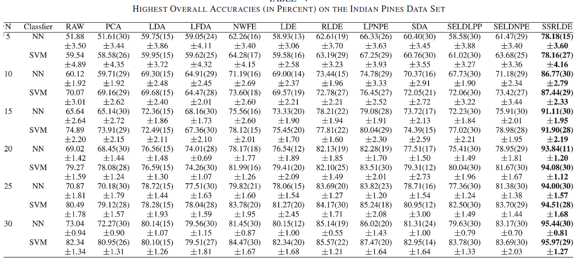
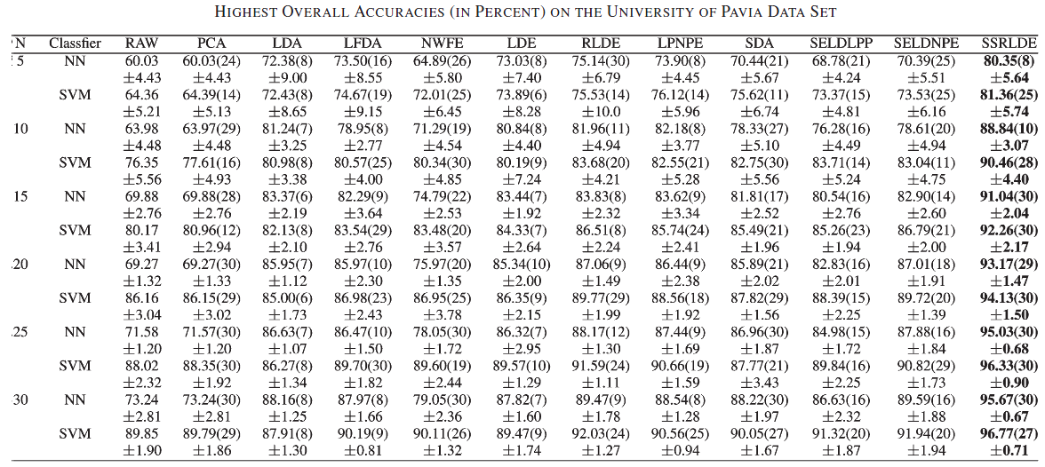
Instead of using the spatial information in classification, we incorporate the spatial information into the DR process of HSIs and propose a spatial and spectral information-based RLDE (SSRLDE) method in this paper. In SSRLDE, the spatial information is used in two ways: spatial filtering and spatial discriminant analysis. Particularly, a multiscale spatial weighted mean filtering (WMF) is used to preprocess the HIS pixels. Then, the multiscale spatial–spectral local discriminant features in the filtered data are extracted by a combination of the spectral-domain regularization LDE (RLDE) and spatialdomain local pixel NPE (LPNPE). Finally, a majority voting method is used to fuse the complementary classification results of each individual scale.
Experimental results:
 |
 |
Reference:
Yicong Zhou, Jiangtao Peng, and C. L. Philip Chen, “Dimension Reduction using Spatial and Spectral Regularized Local Discriminant Embedding for Hyperspectral Image Classification,” IEEE Transactions on Geoscience and Remote Sensing, vol. 53, no. 2, pp. 1082–1698, 2015.